Contributed by McMaster University - No 2 of 3 articles

Chibuike Nnadi - Applied Geophysicist. Student at McMaster University

Alexander L. Peace - Assistant Professor at McMaster University
Introduction
This is the second in a series of blog posts on the Budgell Harbour Stock (BHS), an intrusive gabbroic rock in Newfoundland in Eastern Canada that is of economic interest due to its potential to host platinum group mineralization. These blog posts are entirely based on previously published materials (see acknowledgements and references) that utilised the Full Tensor Gradiometry (FTG) data obtained by Bell Geospace Ltd. in this area. The geological setting of the study area and a basic introduction to FTG was captured in our first post.
What is a geophysical inversion?
How do we go from geophysical data to useful models of the subsurface? This is a question facing many geophysicists. One such approach is through conducting an ‘inversion’. In the simplest sense, an inversion can be described as a process of using observed data and modelling it to produce an estimate of sub-surface structure(s) using a series of mathematical algorithm. In the case of our inversion of the FTG data from the BHS, these equations are outlined in Geng et al. (2019a).
During the study of the BHS, separate density and susceptibility 3-D inversions were undertaken (Geng et al., 2019a), followed by a joint inversion of the FTG and magnetic data together (Geng et al., 2020). These related approaches both provide us with information that can be used to constrain the subsurface structure – and ultimately to provide information on the prospectively of the BHS for mineral exploration. However, these approaches produce slightly different results which are expanded upon below.
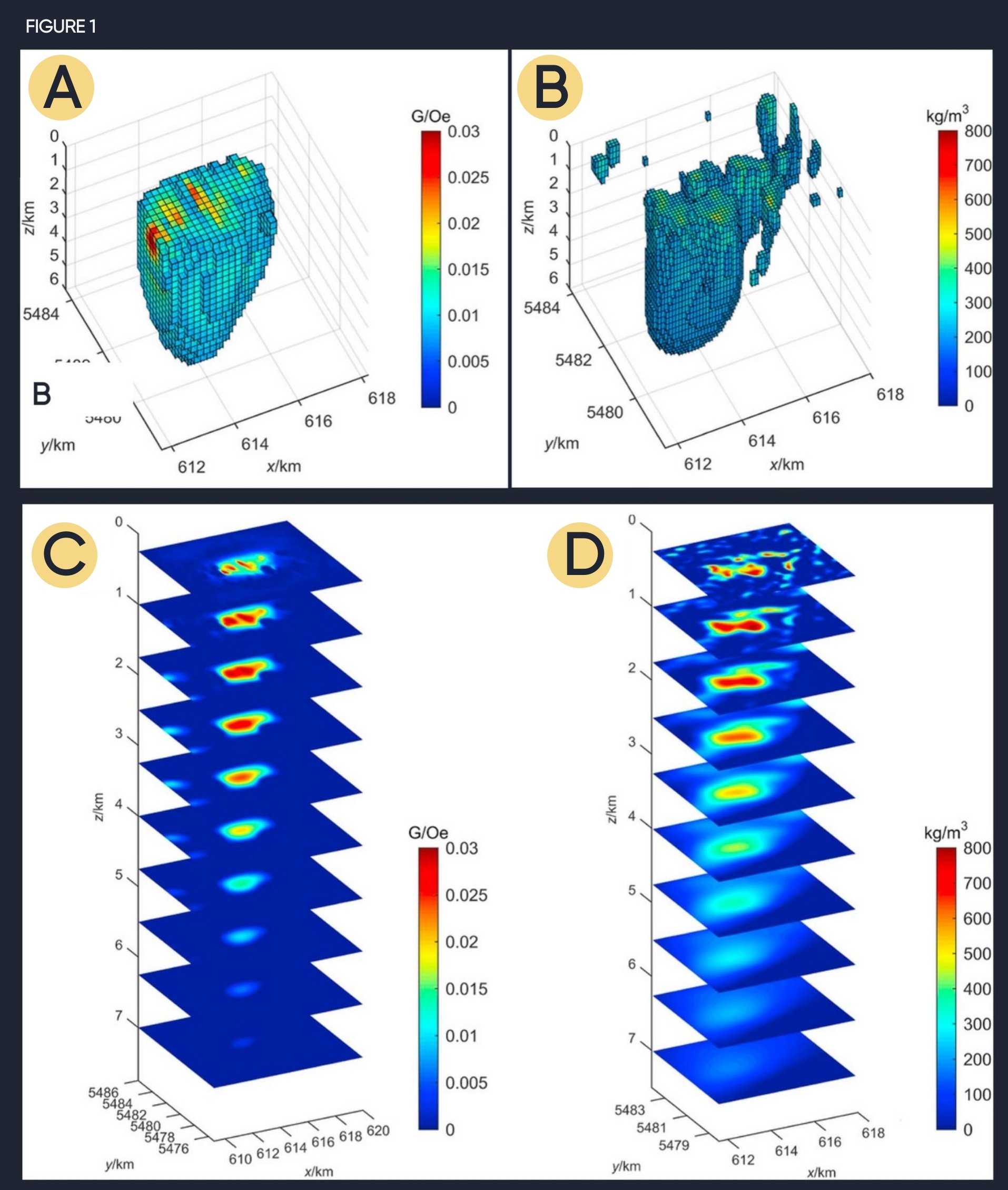
Figure 1 : The results of the inversions of potential-field data viewed from the southwest modified from Peace et al. (2018a)
A) 3D depiction of the results of the inversion of the magnetic data set with susceptibilities< 0.08 G/Oe removed
B) 3- depiction of the results of the inversion of the FTG data set with all points with densities < 200 kg/m3 removed
C) Horizontal slices though the results of the inversion of the magnetic data set
D) Horizontal slices though the results of the inversion of the FTG data set
Results of the inversion – an insight into subsurface structure
The inversion of just the FTG data revealed that the BHS has a depth of approximately 6 km (Fig. 1 A and B) and that laterally the body deepens towards the SW (Peace et al., 2018). This geometry was interpreted by Peace et al. (2018a) to be the result of interaction between the intruding magma and pre-existing structure – a process known as structural inheritance. The joint inversion of both the FTG and magnetic data at the same time gave insights into some of the more small-scale feature of the intrusion.
The inversion of just the FTG data revealed that the BHS has a depth of approximately 6 km (Fig. 1 A and B) and that laterally the body deepens towards the SW (Peace et al., 2018). This geometry was interpreted by Peace et al. (2018a) to be the result of interaction between the intruding magma and pre-existing structure – a process known as structural inheritance. The joint inversion of both the FTG and magnetic data at the same time gave insights into some of the more small-scale feature of the intrusion.
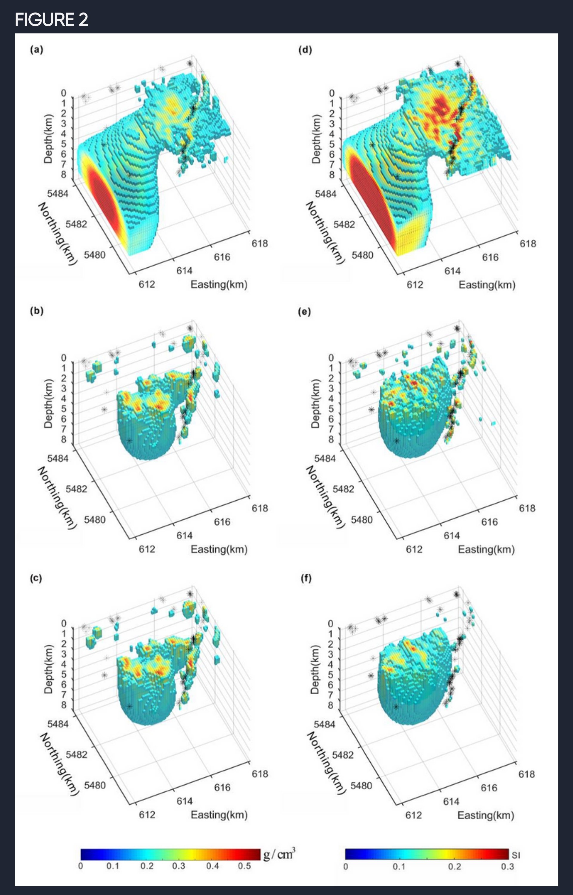
The result of the various inversions conducted (as outlined above) are slightly different partially due to differences in physical properties measured by the inversion input data (i.e. magnetic data measures susceptibility, and FTG data largely measures density etc.). However, the main difference in the input data was the resolution (Figs. 1C and D). The FTG data had a much higher resolution than the magnetic data, emphasising the usefulness of FTG data (Peace et al., 2018a). In addition, the joint inversion of the FTG and magnetic data produced a result thatshowed more small-scale features of the BHS (Fig. 2). This demonstrates why integrating different datasets is particularly useful in obtaining a better understanding of the subsurface geology.
All results however indicated that the BHS has a complex structure comprising multiple parts and magmatic conduits. The geometry of the structure was only made visible through the inversions, demonstrating the importance of 3-D inversion in the exploration and the study of the subsurface.
Of course, an inversion methodology has its own limitation due to the non-uniqueness of the solutions produced, i.e. the model produced depends on the input parameters, and thus an infinite number of possibilities can occur. As such, given this inherent limitation of inversions, there was need to use many constraints as possible e.g., well data and field observations etc. For this reason, we also integrated the data with field observations which are discussed in the next article.
Figure 2. Volume rendered image of the joint inversion results for the BHS using different parameters modified from (Geng et al., 2020)
References
Geng, M., Farquharson, C.G., Welford, J.K., Peace, A.L., Farquharson, C.G., and Peace, A.L., 2019a, 3-D inversion of airborne gravity gradiometry data for the Budgell Harbour Stock, Newfoundland: A case history using a probabilistic approach: Geophysics, doi:10.1190/segam2018-2978510.1.
Geng, M., Welford, J.K., Farquharson, C.G., and Peace, A.L., 2018, 3-D inversion of airborne gravity gradiometry data for the Budgell Harbour Stock: A case history of using a probabilistic approach, in Society of Exploration Geophysicists (SEG) October 14th-19th 2018, Anaheim, Ca, USA, doi:10.1190/segam2018-2978510.1.
Geng, M., Welford, J.K., Farquharson, C.G., and Peace, A.L., 2019b, 3D joint inversion of airborne gravity gradiometry and magnetic data : A case study, in Society of Exploration Geophysicists (SEG) 15th-20th of September, San Antonio, TX, USA, doi:https://doi.org/10.1190/segam2019-3208039.1.
Geng, M., Welford, J.K., Farquharson, C.G., Peace, A.L., and Hu, X., 2020, 3-D joint inversion of airborne gravity gradiometry and magnetic data using a probabilistic method: Geophysical Journal International, v. 223, p. 301–322, doi:10.1093/gji/ggaa283.
Peace, A.L., Welford, J.K., Geng, M., Sandeman, H., Gaetz, B.D., and Ryan, S.S., 2018a, Rift-related magmatism on magma-poor margins: Structural and potential-field analyses of the Mesozoic Notre Dame Bay intrusions, Newfoundland, Canada and their link to North Atlantic Opening: Tectonophysics, v. 745, p. 24–45, doi:10.1016/j.tecto.2018.07.025.
Peace, A.L., Welford, J.K., Geng, M., Sandeman, H., Gaetz, B.D., and Ryan, S.S., 2018b, Structural geology data and 3-D subsurface models of the Budgell Harbour Stock and associated dykes, Newfoundland, Canada: Data in Brief, p. 1–7, doi:10.1016/j.dib.2018.10.072.
Strong, D.F., and Harris, A., 1974, The Petrology of Mesozoic Alkaline Intrusives of Central Newfoundland: Canadian Journal of Earth Sciences, v. 11, p. 1208–1219, doi:10.1139/e74-114.
Stuckless, E., 2008, Celtic Minerals Assessment Report discussing Geochemistry, Geophysics, and Diamond Drilling on the Budgell’s Harbour Property, Central Newfoundland