Contributed by McMaster University - No 3 of 3 articles

Chibuike Nnadi - Applied Geophysicist. Student at McMaster University

Alexander L. Peace - Assistant Professor at McMaster University
Introduction
This is the third in a series of blog posts on the Budgell Harbour Stock (BHS), an intrusive gabbroic rock in Newfoundland in Eastern Canada that is of economic interest due to its potential to host platinum group mineralization. These blog posts are entirely based on previously published materials (see acknowledgements and references) that utilised the Full Tensor Gradiometry (FTG) data obtained by Bell Geospace Ltd. in this area.
The first post focused on the general introduction and the second post focused on the inversion of the FTG data. In this blog post, we will focus how field data and observations were used to constrain the subsurface geology.
Field geology and mapping of the BHS and related intrusions
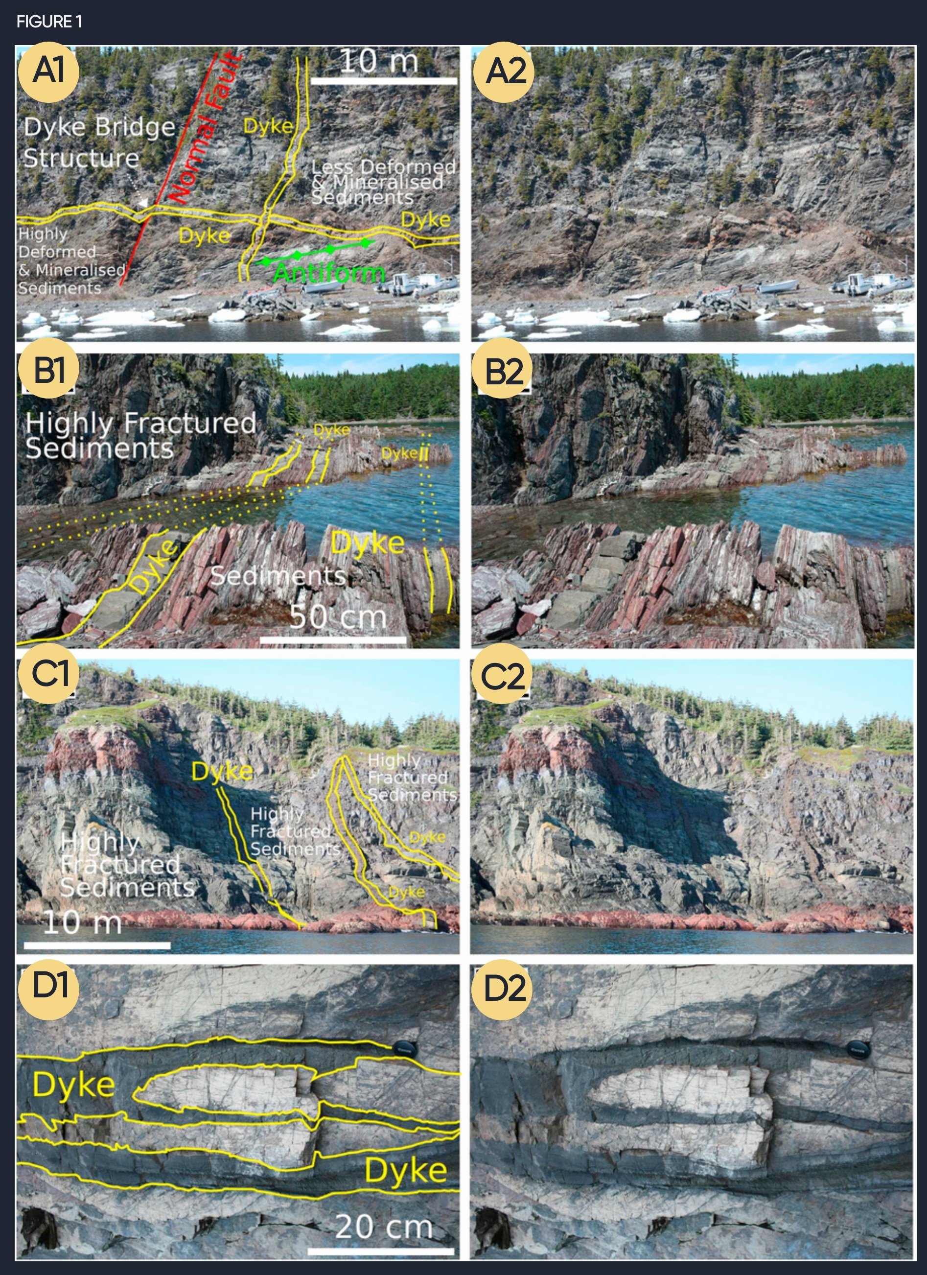
Although the BHS is a substantial subsurface feature, its surface exposure is very limited. This is not a problem that is unique to the BHS – with similar challenges faced generally when working on many exploration projects. In addition, the exposures that do exist are located far from roads, in dense vegetation or marshes. Widespread dykes however are exposed which are interpreted to have been intruded alongside the BHS – therefore making them the ideal candidate to study to learn more about the BHS. By mapping the locations, orientation and structure of these dykes, which were largely accessed by boat, important information about the geological evolution, and the prospectively of the BHS became apparent.
Figure 1 - This figure of interpreted and uninterpreted field images of lamprophyre dykes in Notre Dame Bay is modified from Peace et al. (2018a). A1–2) A low-angle dyke being crosscut by a high-angle dyke. The low angle dyke has a minor bridge structure associated with a normal fault that does not appear to have been deformed post-intrusion and a change in orientation, coincidental with an antiform in the sediments. B1–2) Multiple high-angle sills intrude, parallel to bedding. C1–2) Field example of three well exposed high-angle dykes crosscutting sedimentary rocks. D1–2) Small-scale dyke fingering into dykelettes near the termination of a dyke” (Peace et al., 2018).
Subsurface Interpretation
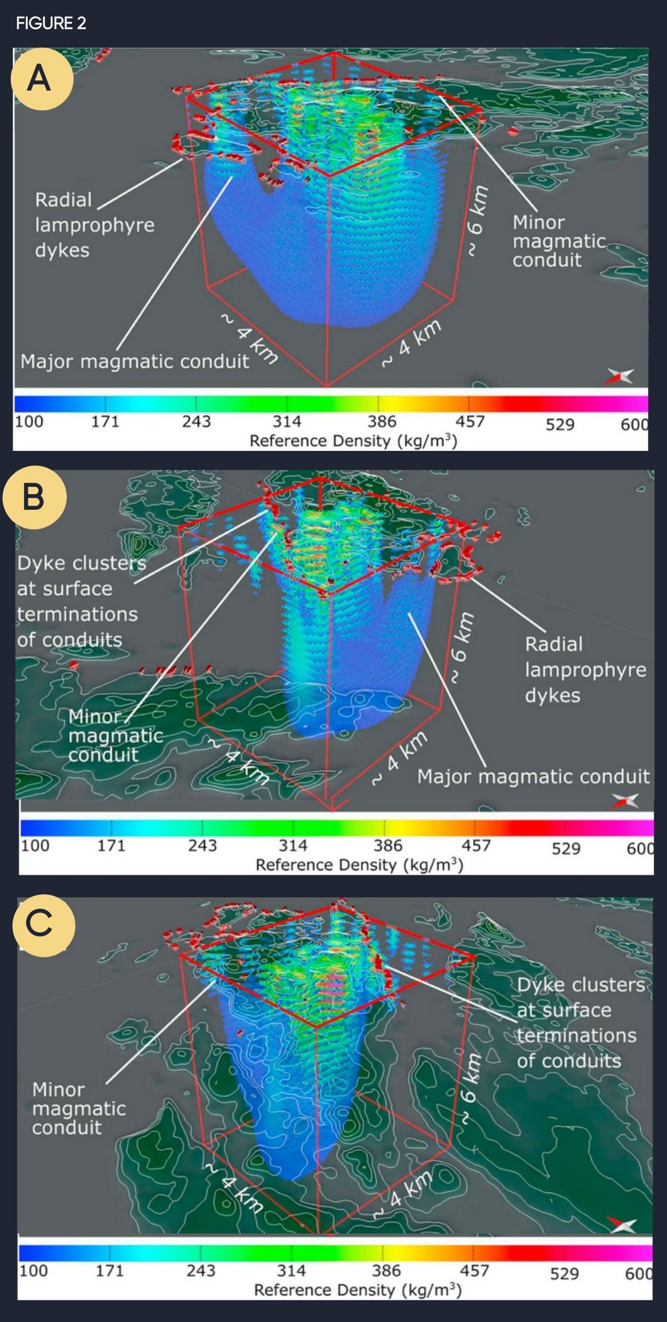
Through a series of field campaigns our team mapped hundreds of dykes. The field mapping showed that the BHS was surrounded by a radial dyke swarm which had also been noted by previous work. However, it is when these data were integrated alongside the subsurface geophysical models that deeper insights were obtained.
Comparison of the dyke locations with the results of the FTG inversion (described in blog post 2 and shown in Fig. 2 here) indicated that the dykes are themselves radial around the separate magmatic lobes or conduits, in addition to the whole swarm being radial. This relationship would not have become apparent without the integration of the subsurface geophysics, including the FTG data, and the exposure of outcrops at the surface. The result of this is that the dykes surrounding the BHS are possibly fed by different conduits which are shown on the FTG inversions. The implication of this for exploring the BHS is that it has possibly intruded in several stages which could affect mineralization.
Use of just field or subsurface observations would not have been able to yield these insights, and therefore, this study has demonstrated the value that the FTG data can add to field observations (Fig. 1) and vice versa.
Figure 2 shows 3-D images of the results of the inversion of the FTG data cropped at a reference density of 100 kg/m3 in addition to the locations and orientations of lamprophyre dykes and is modified from (Peace et al., 2018a). In this figure the BHS is viewed from A) SW, B) NE and C) NW.
References
Bell, R.E., 1998. Gravity gradiometry, Scientific American, vol. 278, No. 6, pp. 74-79.
Droujinine, A., Vasilevsky, A., and Evans, R., 2007, Feasibility of using full tensor gradient (FTG) data for detection of local lateral density contrasts during reservoir monitoring: Geophysical Journal International, v. 169, p. 795-820, doi:10.1111/j.1365-246X.2007.02806x.
Geng, M., Farquharson, C.G., Welford, J.K., Peace, A.L., Farquharson, C.G., and Peace, A.L., 2019a, 3-D inversion of airborne gravity gradiometry data for the Budgell Harbour Stock, Newfoundland: A case history using a probabilistic approach: Geophysics, doi:10.1190/segam2018-2978510.1.
Geng, M., Welford, J.K., Farquharson, C.G., and Peace, A.L., 2018, 3-D inversion of airborne gravity gradiometry data for the Budgell Harbour Stock: A case history of using a probabilistic approach, in Society of Exploration Geophysicists (SEG) October 14th-19th 2018, Anaheim, Ca, USA, doi:10.1190/segam2018-2978510.1.
Geng, M., Welford, J.K., Farquharson, C.G., and Peace, A.L., 2019b, 3D joint inversion of airborne gravity gradiometry and magnetic data : A case study, in Society of Exploration Geophysicists (SEG) 15th-20th of September, San Antonio, TX, USA, doi:https://doi.org/10.1190/segam2019-3208039.1.
Geng, M., Welford, J.K., Farquharson, C.G., Peace, A.L., and Hu, X., 2020, 3-D joint inversion of airborne gravity gradiometry and magnetic data using a probabilistic method: Geophysical Journal International, v. 223, p. 301–322, doi:10.1093/gji/ggaa283.
Peace, A.L., Welford, J.K., Geng, M., Sandeman, H., Gaetz, B.D., and Ryan, S.S., 2018a, Rift-related magmatism on magma-poor margins: Structural and potential-field analyses of the Mesozoic Notre Dame Bay intrusions, Newfoundland, Canada and their link to North Atlantic Opening: Tectonophysics, v. 745, p. 24–45, doi:10.1016/j.tecto.2018.07.025.
Peace, A.L., Welford, J.K., Geng, M., Sandeman, H., Gaetz, B.D., and Ryan, S.S., 2018b, Structural geology data and 3-D subsurface models of the Budgell Harbour Stock and associated dykes, Newfoundland, Canada: Data in Brief, p. 1–7, doi:10.1016/j.dib.2018.10.072.
Strong, D.F., and Harris, A., 1974, The Petrology of Mesozoic Alkaline Intrusives of Central Newfoundland: Canadian Journal of Earth Sciences, v. 11, p. 1208–1219, doi:10.1139/e74-114.
Stuckless, E., 2008, Celtic Minerals Assessment Report discussing Geochemistry, Geophysics, and Diamond Drilling on the Budgell’s Harbour Property, Central Newfoundland